
Our park is locally known as the ‘Brickfield’, so it’s not at all surprising that it’s the site of an ‘extensive’ brick works, from the Victorian era, right through to 1934. It was on the southern boundary of the estate of Coles-Child, Lord of the Manor (not sure if that was meant to be complementary) who had bought the Manor of Bromley from the Diocese of Rochester. They extracted the London Clay (initially) for brick making, and when this was exhausted, the underlying gravels and sands, of the Lambeth group, but also called ‘Woolwich and Reading Beds’, for local construction. In the first half of the 1800’s the local supply of bricks had been from more and smaller local pits (no-one carried bricks further than they needed to); there are several marked in the area on the 1868 map. Though the mid-1800’s Bromley expanded enormously, and there was a ready market for bricks, and sands and gravels, for the local construction industry; the brickpit here expanded accordingly. Bricks from this brickworks were used in the construction of the railway (it was a condition of it passing through Coles-Childs land) and the new town hall.
Under our feet (the stratigraphy):
Bromley is at the southern end of the London Basin, a syncline (downward bend of the rocks) from the chalk of the Chilterns in the north, to the chalk of the South Downs. Here is an illustration of the concept from 1843:

So, working downwards, the sedimentary layers of ‘rock,’ beneath this local area, are:
|
“Deposition of the Thanet Formation, Lambeth Group and Harwich Formation occurred in embayments on the western margin of a deep-water marine basin of the North Sea. These marginal deposits were very sensitive to relatively minor changes in sea level. This resulted in alternating incursions and recession of the sea and migration of depositional environments, followed by erosion, changes in groundwater levels, soil formation and down-cutting by rivers that contributed to the development of complex lithologies. Rising sea level led to rapid inundation and a new phase of sedimentation. ”
“The Thanet Formation is also preserved locally in dissolution pipes and hollows in the Chalk ”
“The sediments are intensely bioturbated so that primary sedimentary structures such as lamination are generally missing.”
Engineering Geology Directorate Open Report OR/13/006 http://nora.nerc.ac.uk/503110/1/EngGeol_Lambeth_FINAL_1.02.pdf
A map of where these layers outcrop in our area:

The layers are almost horizontal (as opposed to being tilted) but have irregularities, apparently from the extension of basement faulting and ice age features such as pingos.
The BGS (British Geological Survey) archive of assets has photographs of some of the local brickpits.
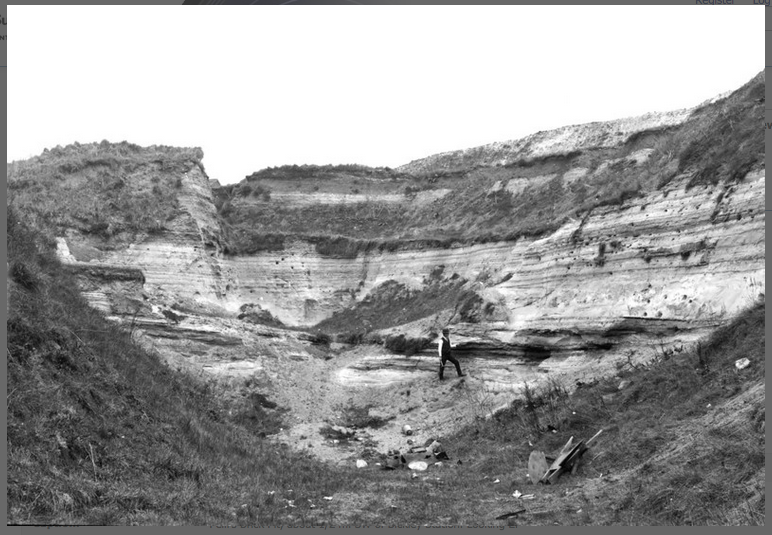
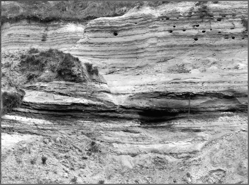
These photos were taken in 1921, when our Brickfield was a huge hole in the ground, and called Peill’s Brick Pit. It closed in 1934 on the death of it’s proprietor, James John Peill. BGS Geo-Scenic archive asset number P201862. Caption “The Blackheath Pebble Beds. This view is taken to show the even-bedded sand and loam passing downwards into current-bedded sands. Pebbles are rare, but a bed of them occurs near the figure.”
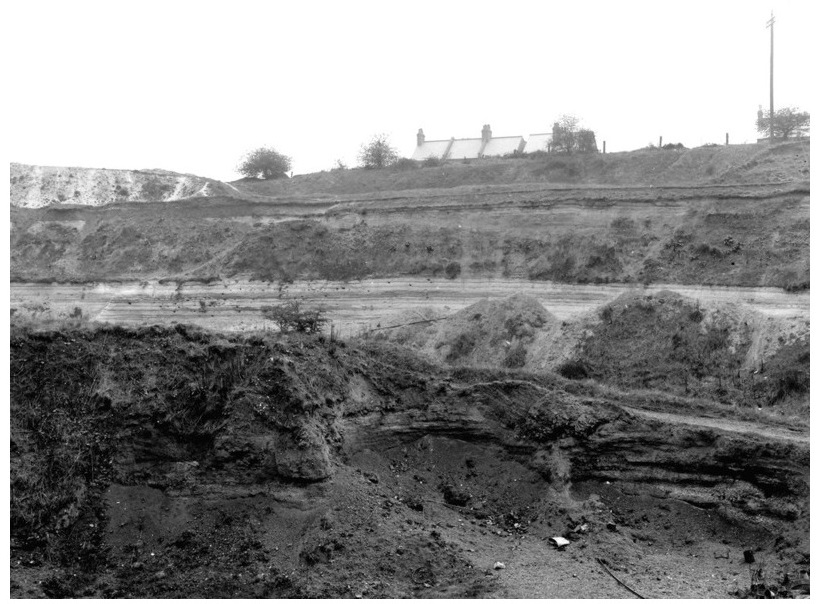
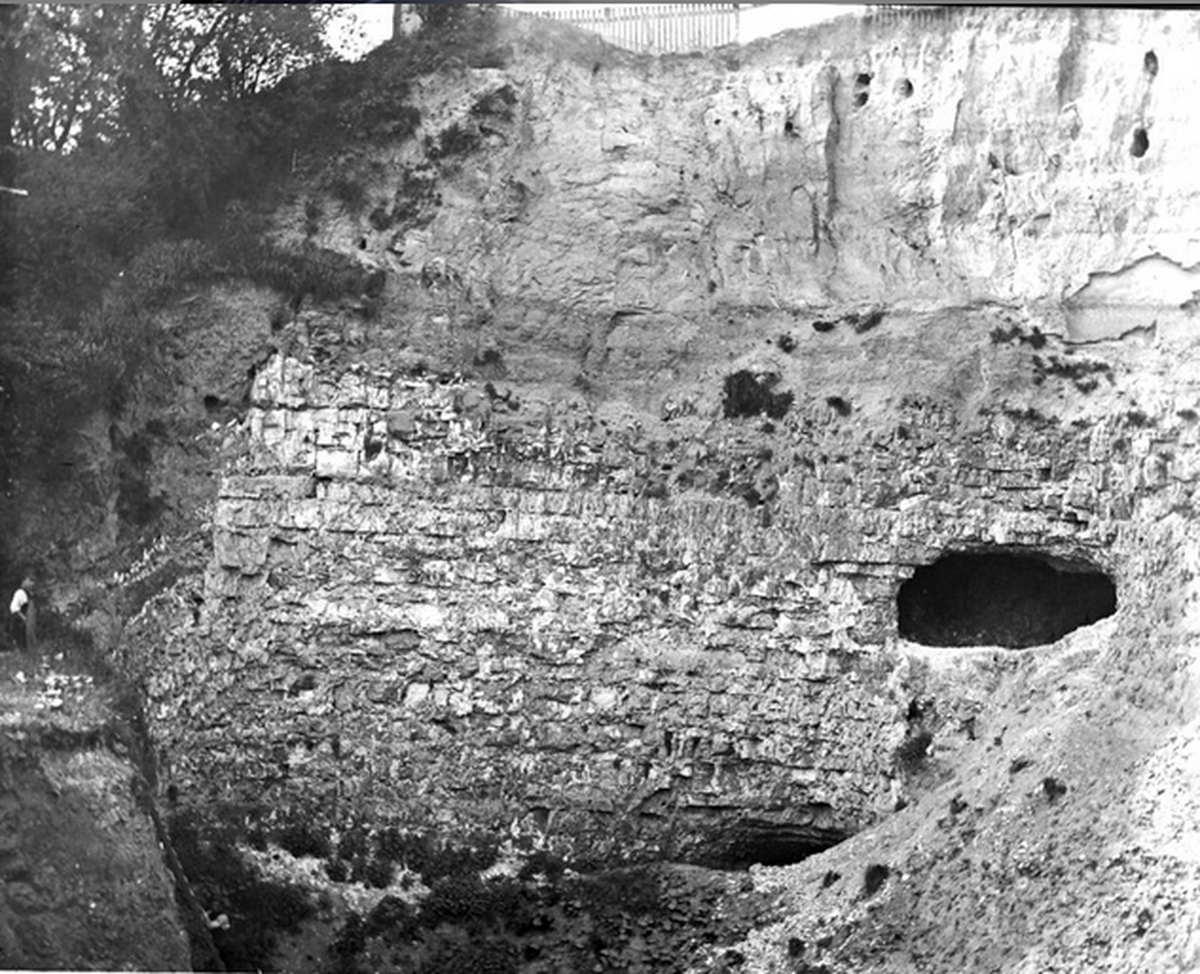
BGS asset number 201860. Old Photograph number A01901. Date Taken: 01/04/1921. Photographer: Rhodes J. Looking South. London Clay overlying Blackheath Beds. The London Clay forms the beds at the top of the section extending downwards to the light coloured beds. On the left is partly hidden by a mass of dumped chalk used in making white brick. The base of the London Clay consists of a bed of pebbles up to 3 feet thick, below which are 24 feet of even-bedded sand and loam overlying 38 feet current-bedded pebbly sand.
BGS asset number 201864. Old Photograph number A01913. Date Taken: 01/04/1921. Photographer: Rhodes J. Looking south-east. The Blackheath Pebble Beds. This photographs shows the irregular distribution of pebbles in the sand and the cross bedding.
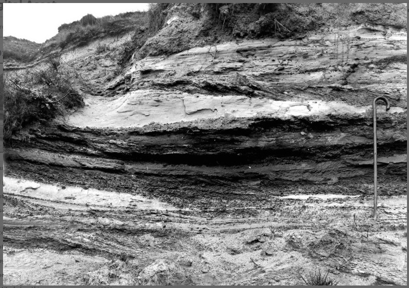
BGS asset number 201863. Old Photograph number A01912. Date Taken: 01/04/1921. Photographer: Rhodes J. Looking south. The Blackheath Pebble Beds. A nearer view of No. 01911 showing the even-bedded sand and loam overlying current-bedded sand and pebbles.
Looking at this photo you can tell things about the environment where it was laid down. The even bedded sands towards the top of the photo would have been laid down in a place where there was enough wave energy to prevent too much clay settling. The layers where the sand becomes coarser and turns into gravel would have had even more energy as the sand hasn’t settled. It is probable that the more pronounced layers were put down in an individual storm event. Towards the bottom you have a scooped shape exposed – this is a channel that was cut through the other sand by a river or tidal flow.
(note: the fine walking stick used to give an idea of scale to the photo. And the sand martin nests)
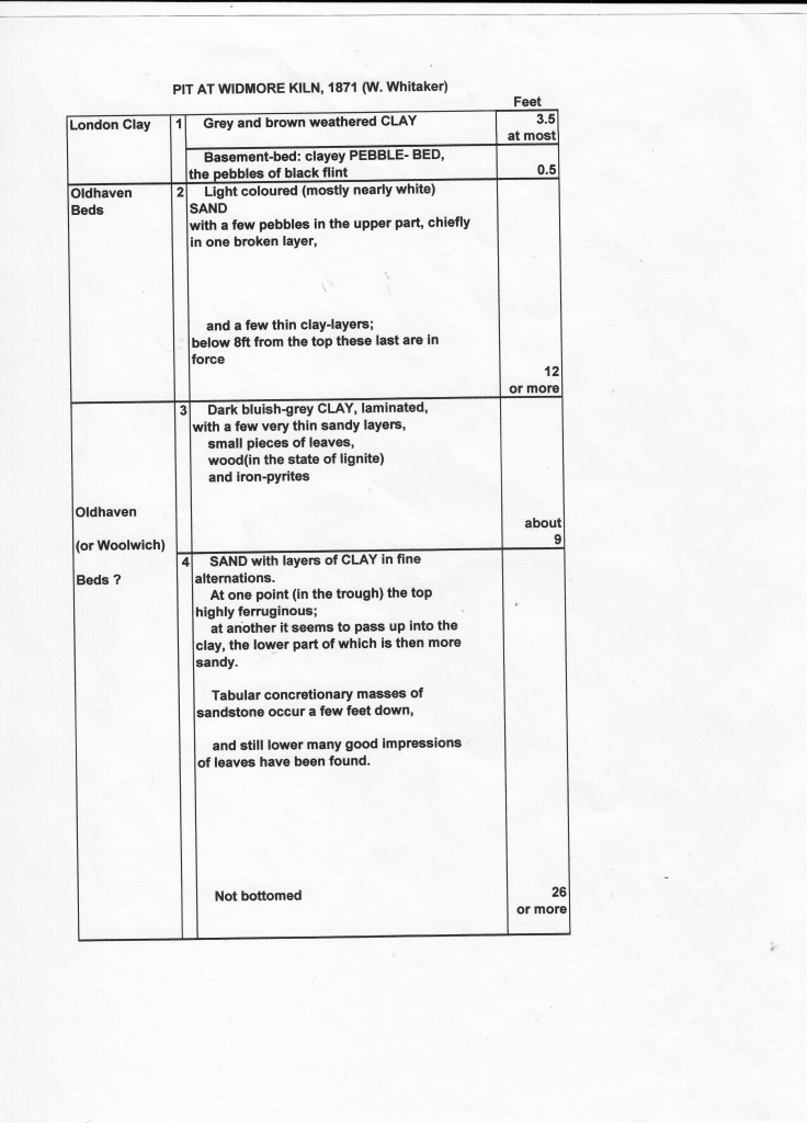
Geologist’s Association Field Trips to nearby Widmore Pit:
On several occasions, the Geologist’s Association undertook field trips and studies to local features such as Widmore Pit, and the exposures by the Penge Tunnel. This drawing was done on one of these field trips in 1871 and illustrates the structures exposed in the pit walls at this time.
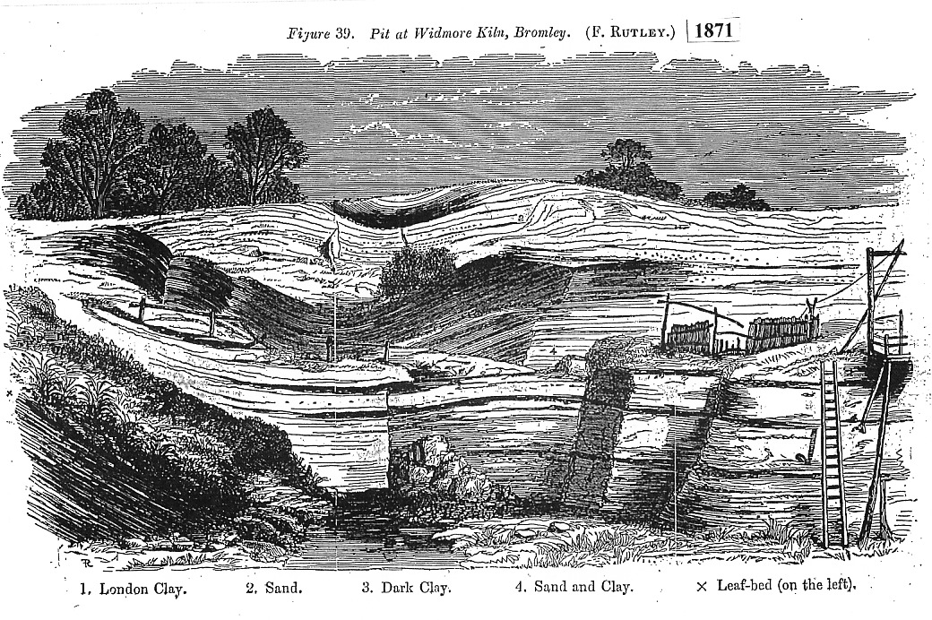
Much thanks to Paul Rainey for his detective work in the GA archives that discovered this material. He has previously used it to compile a display in the Bromley Museum at the Priory, Orpington, but it is not clear what will become of this collection.
References for Paul’s work:
From Greater London Industrial Archaeology Society (GLIAS):Lime burning was not the only extractive industry in Chislehurst. Further east (confusingly, in the area known as Chislehurst West) there were at least two brickworks on London Clay…
Sand was also extracted. Whitaker (1872) noted a large old pit in Thanet Sand on the south of the road to Bromley (ie, Old Hill) ¾ mile west of Chislehurst church. In 1866 he found that its floor was the layer of hard chalk which served as the roof of the galleries at Camden Park. (see photo of Camden Park Pit below):
BGS asset P201414 taken in 1889 by HC McNeill, captioned “Camden Park Pit, Chiselhurst. Chalk, with horizontal excavations, overlain by Thanet Sands.”
6,256 total views, 1 views today