This page is a potted explanation of the rocks (or more like clay) that underlies Bromley, to give a bit of background to the photos of the brick-pit when it was working.
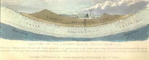
Bromley is at the southern end of the London Basin, a syncline (downward bend of the rocks) from the chalk of the Chilterns in the north, to the chalk of the South Downs. Here is an illustration of the concept from 1843:
So, working downwards, the sedimentary layers of ‘rock,’ beneath this local area, are:
|
“Deposition of the Thanet Formation, Lambeth Group and Harwich Formation occurred in embayments on the western margin of a deep-water marine basin of the North Sea. These marginal deposits were very sensitive to relatively minor changes in sea level. This resulted in alternating incursions and recession of the sea and migration of depositional environments, followed by erosion, changes in groundwater levels, soil formation and down-cutting by rivers that contributed to the development of complex lithologies. Rising sea level led to rapid inundation and a new phase of sedimentation. ”
“The Thanet Formation is also preserved locally in dissolution pipes and hollows in the Chalk ”
“The sediments are intensely bioturbated so that primary sedimentary structures such as lamination are generally missing.”
Engineering Geology Directorate Open Report OR/13/006 http://nora.nerc.ac.uk/503110/1/EngGeol_Lambeth_FINAL_1.02.pdf
A map of where these layers outcrop in our area:

The layers are almost horizontal (as opposed to being tilted) but have irregularities, apparently from the extension of basement faulting and ice age features such as pingos.
4,138 total views, 4 views today

